Explore the past with East Riding Archives' 'What was Here' App
Wed 14th August 2019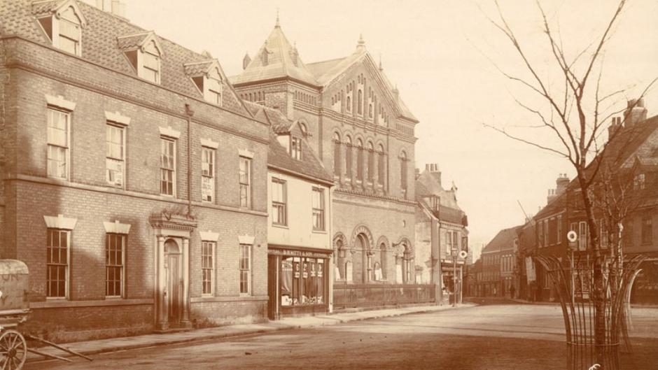
We humans are a curious bunch. How many times have you been stood, looking out at your surroundings and wondered ‘What’s that for?’, ‘Why is that there?’, or even ‘What was here?’. These are some of the basic questions that drive our curiosity, and we’ve all asked them at some point, maybe some of us ask them every day. The frustrating thing is that we won’t always be able to find the answer to that niggling curiosity and, worse still, we may not even know where to begin looking.
The passage of time ensures that once a thing is gone, it’s gone forever, and so the answer to our question of ‘What was here?’ is perhaps one of the most difficult to satisfy. It’s not like you can just stand in a place and travel back in time to see what it looked like in the early 1900s for example; that’s just not possible, right?. Well, it wasn’t. Until now.
At East Riding Archives they’ve launched a free app that turns your smartphone or tablet device into a virtual ‘time machine’. ‘What Was Here?’ uses historical photos from the archives, plotted onto a Google Maps base map, to show you literally ‘what was here’ at your location in Beverley and all across the East Yorkshire region.
The ’What Was Here?’ app lets you see available historic photos that are relevant to where you are standing. This means that you can use the ‘What Was Here?’ map to do self-directed exploration of your local area and see how it used to look. It gives you a window to look back through time. A window on the past.
Needless to say, this is not actual, real time travel, but it’s literally the closest you’re going to get to being able to transport yourself back in time to see what your immediate surroundings looked like in the past!
If you’re wondering how all this came about, well it was when Sam Bartle, digital archivist at East Riding Archives, was walking into work one day. As he went down Long Lane, smartphone in hand, alongside the meadow south of Beverley Minster, he glanced up and recognised the scene in front of him as being the spot where a photograph was taken in 1939. The subject of the photograph was renowned artist Fred Elwell as he painted The Admiral Duncan Inn, and the image is preserved at East Riding Archives.
Gazing across a plain meadow, with an unobstructed view of the Minster, Sam also remembered the buildings from the photograph, that used to occupy this area, and thought to himself “I bet that not many people know what was here.” In the instance of that internal monologue, the germ of an idea was born. This wasn’t just something that applied to the land around Beverley Minster, but was relevant to anywhere in which a photograph had been taken and had witnessed the passage of time.
Using the power of smartphone and GPS technology, combined with the heritage collections from the archives, the knowledge of what used to be at a given location, or how it used to look, could be shared far and wide to people’s devices. So began the long process for Sam to bring this new digital project from concept through to development, and finally to its public delivery.
The ‘What Was Here?’ app also features heritage trails that guide you to various points of interest, where you can apply an augmented reality function in which you use your device’s camera to overlay the featured historic image on top of the modern scene and get a feel for how it looked in the past.
One such heritage trail is currently part of the Sewerby Hall & Gardens visitor experience (admission charge applies), and there are three in Beverley; a ‘Childrens’ Explorer Trail’ (must be accompanied by adults at all times) a ‘Festival Of Words’ literary trail (as in-app purchase), and a ‘Walking & Outdoors Festival’ trail. However, the great thing about this is app is that it can be of use to you almost anywhere across the East Yorkshire area: You could be in Stamford Bridge one day, and all the way over in Withernsea the next, and still you’ll find it possible to while away a few minutes exploring the past of these places with the free ‘What Was Here?’ app.
It’s a self-directed exploration tool, and if you really like what you see on the app, you can also buy prints of selected images by following links through to the East Riding Photos website.
Obviously, it can only be as good as the collections, or images that East Riding Archives are able to upload, so the initiative is also a crowdsourcing project, in which you can donate your historic images to the Archives for permanent preservation and potential upload onto the ‘What Was Here?’ platform.
Users can also suggest corrections to location coordinates, so that the image points can be made as accurate as possible to maximise the visual effect of comparing past with present.
‘What Was Here?’ is free and available now on Google Play Store and the App Store (search ‘what was here’). You can also check out the accompanying website at www.whatwashere.org
More details can be found at www.eastridingarchives.co.uk under ‘Archives Online’.
Direct links to app stores:
Google Play https://play.google.com/store/apps/details?id=com.surfaceimpression.eastridings
App Store
https://apps.apple.com/az/app/what-was-here/id1453854091
The picture shows Wednesday Market with its grand Primitive Methodist Chapel prior to 1957. Perhaps you remember it?